A Planning Application has been submitted for the “Hedgehog Grove Solar Farm” that was originally
pursued as a Nationally Significant Infrastructure Project (NSIP), meaning that the final decision on whether permission for development was approved would be made the Secretary of State on behalf of the
Government, but this was subsequently withdrawn.
However, following changes made by the Government in December 2025 under the Planning and
Infrastructure Act 2025, there is now no specific “maximum” power output that a solar farm is legally
prohibited from exceeding; rather, the Act redefines the regulatory pathways for projects of varying scales.
The most significant change introduced by the Act and its associated secondary legislation is that the act
raises the capacity limit for solar farms that can be decided by local planning authorities under conventional Planning Applications from 50 MW to 150 MW. This means that solar farms can now produce up to 150 MW of power while remaining under the local planning regime, in our case, that is via Uttlesford District Council (UDC).
Felsted residents are able to comment to UDC on the application now it is formally submitted. No doubt
some residents may choose to support the application, and some will object.
The Neighbour Consultation Expiry Date is……….…Saturday 16 May 2026
Details of the application (and the opportunity for those residents who wish to comment) can be found at:
https://publicaccess.uttlesford.gov.uk/online-applications/search.do?action=simple&searchType=Application
By entering the application reference number UTT/26/0445/FUL
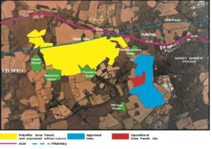
Felsted Parish Council has objected because we have already supported TWO solar farms within Felsted
Parish, one covering 38 acres (shown in red on the map below) which has been fully operational since
2014 and the other covering 282 acres (shown in blue on the map below), which received full planning
approval from UDC in 2023 but is yet to be constructed. Both located near Willows Green.
Our concern is the scale of the proposal and the cumulative impact of the existing approved 320 acres plus the proposed additional 675 acres (shown in yellow on the map below) which would bring the total
combined area of Felsted under “Solar” to circa 1,000 acres or 405 hectares, seriously impacting our rural
environment and displacing wildlife etc. In addition, the majority of the impacted land, according to the
Natural England – Agricultural Land Classification map for the Eastern Region (ALC008) would be on land
classified as “Grade 2” i.e. “Very Good” BMV (Best and Most Versatile) or Grade 3a “Good” agricultural
land.
The use of almost 1,000 acres of what is classified as BMV Grade 2 “Very Good” or Grade 3a “Good” land
is considered unacceptable and unsustainable.